This is an old post that was found on my previous website. I am archiving it here, it was originally published in December 2015.
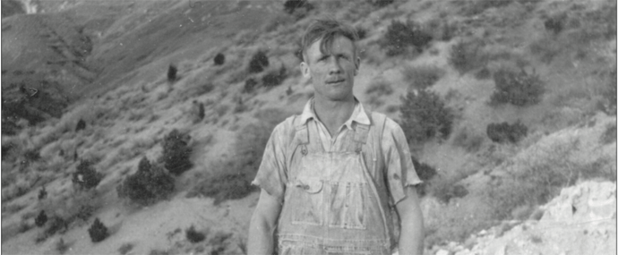
This morning, while enjoying my breakfast, drinking coffee, and reading my hometown newspaper, The Nephi Times-News, I was intrigued by an old photo of an unidentified man, wearing dusty overalls and standing on an outcrop of rock in the foothills of a mountain. Behind him, a large “N” emblazoned on the hill. The photo was ran by the newspaper as part of their “Blast from the Past” feature, essentially a #ThrowbackThursday featuring vintage images of people and the area brought in by members of the community. (As a sidenote that really has nothing to do with this post other than the fact that I’m still reading my hometown paper, the Times-News has been run by my family for ~5 generations, my father and sister are currently the Publisher and Editor, respectively.)
The photo caught my eye. It is a captivating image in itself. I’ll never know who the man is. But the geologist in me is wondering where he is and what he is doing. So, I poured myself another cup of coffee and decided to chase this little mystery.
I grew up in Nephi, Utah (a small community of around 5,000 people), in the shadow of Mount Nebo. Mt. Nebo is the southernmost and also the tallest mountain of the Wasatch Range (at a modest elevation of 11,928 ft/3,636 m above sea level). I’d recognize Nebo anywhere, having spent a lot of time hiking its lower slopes, playing in its canyons, and admiring its geology and wilderness. Nebo is like an old friend that never changes (well, incrementally changes over geologic time, anyways).
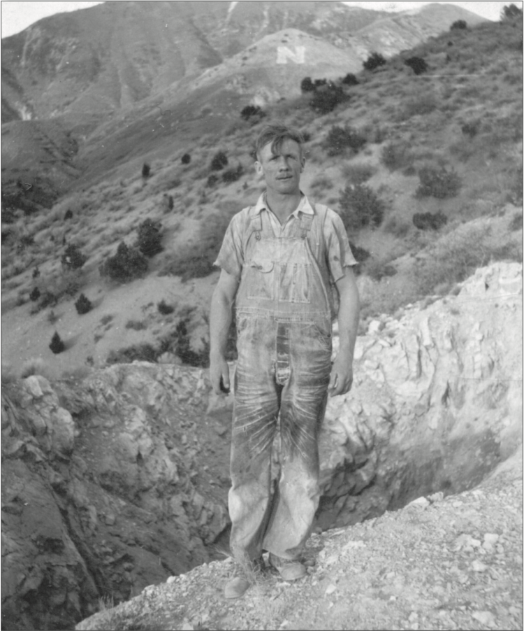
The mountain in the far background of the image is Nebo’s southern slope, and is what is most visible to the residents of Nephi (the actual peak is farther north, closer to Mona, Utah).
Now, non-westerners might be wondering, what’s up with the “N” on the hill? Something that was so common to me growing up in Utah is like some wacky mystery to others not from a mountainous region (this is based upon my experience in the midwest). So, to give a quick and dirty explanation: in most cases in Utah, the letters represent the nearest highest-level school. For example, if you find yourself in Provo, Utah, the highest-level school is Brigham Young University, symbolized by a giant “Y” on the hill. In Nephi, the highest-level school is the local high school. It’s just some way of establishing territory/dominance/school pride by the local community.
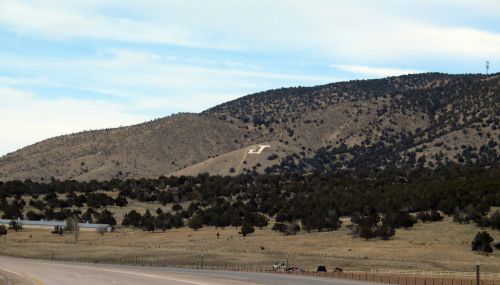
According to The Times-News, the “N” stands for Nephi High School, which was the name of the school until 1932, when it was changed to Juab High School (for Juab County), my alma mater. (Go Wasps!) So that gives this image a minimum age of 1932. Mystery 1 solved, sort of. I’m sure someone could analyze his clothing or hairstyle, or the type of film used to figure out a more precise age of the photo, but out of my realm.
Mystery 2: the placement of the “N.” What was most obvious to me is that the “N” is in the wrong place. Now, of course the “N” isn’t there anymore; when it changed to JHS obviously the letter on the hill was changed to a “J” where still today the seniors of the high school give it a fresh coat of paint each year during homecoming week. But the “J” is on a much lower hill, closer to the freeway. This “N” seems higher, and doesn’t feel right to me. Where is it exactly? Enter Google Earth. Using the shape of Nebo and the foothills, and exposed geologic outcrops, I figured it out. Although the image is in black and white, there is a obviously change in the texture and color along the lower left of the hill and it’s lower slopes. The “N” is obviously on the that flattened/smooth part of the hill spur, far away from where the current “J” is! Mystery 2: solved definitely!
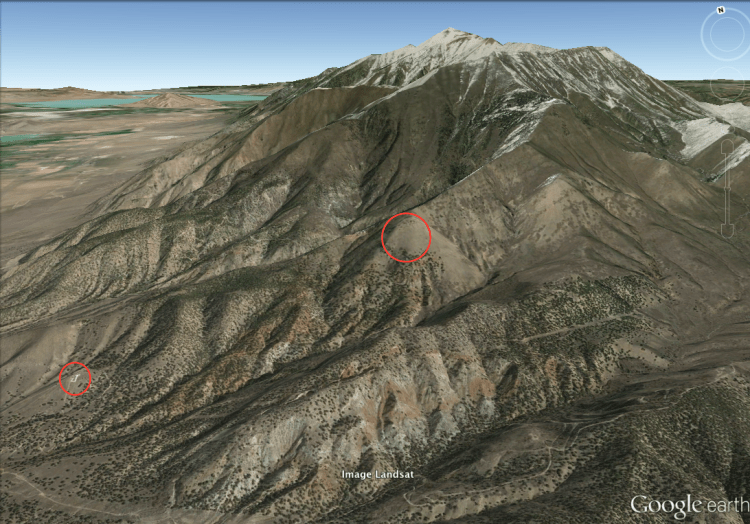
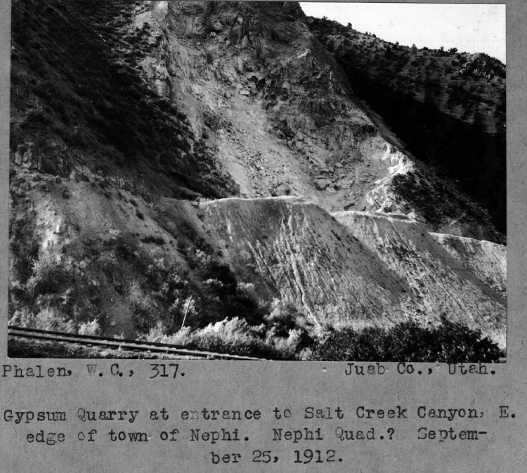
Mystery 3: Where is the man and why is he so dusty? My first inclination is that he’s mining gypsum. At the mouth of Salt Creek Canyon (which runs east of Nephi, through the mountains south of Nebo and into Sanpete Valley), there is a gypsum mine that has been operational since its discovery in 1889. However, this man is not at the large gypsum mine, but at some small outcrop north of the mine in the canyon. I pinpointed my guess of his location below.
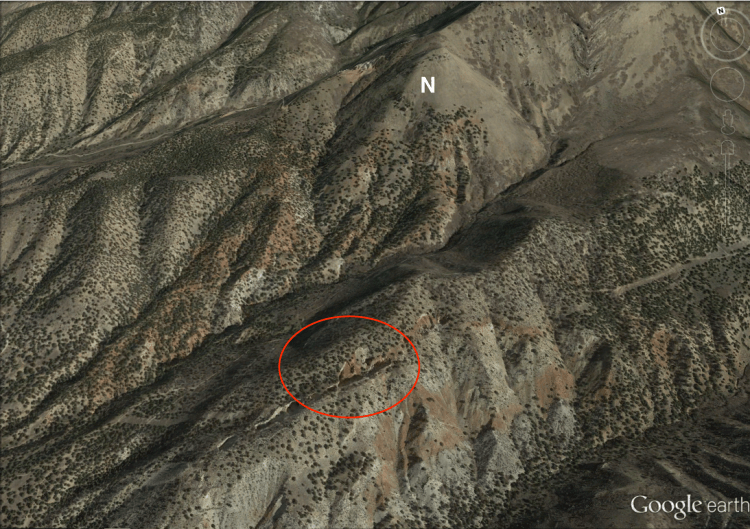
Thankfully, the Utah Geological Survey provides interactive topographical geologic maps, so one I had used Google Earth to approximate his location, it was very easy to see that he was standing in a smaller, northern exposure of the same gypsum deposits, which are in the Arapien Shale. The Arapien Shale is middle Jurassic in age, and comprises mudstones, shales and some limestones rich with evaporites, such as salt and gypsum. Pioneers that first settled the area noted the salty creek (hence Salt Creek Canyon), and traced the origin of the salt back to some of these salt deposits in the Arapien, where they are also mined in addition to the gypsum.
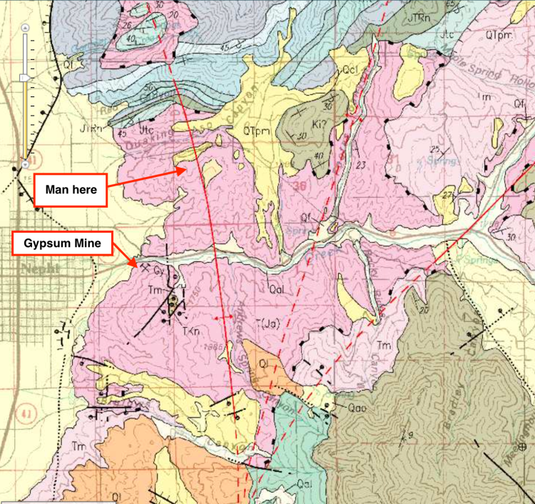
The interesting thing about the Arapien Shale is that it was severely deformed and twisted during the Sevier Orogeny (mountain-building) event that created the Wasatch mountains during the Cretaceous and Tertiary. Some of the thrusting and folding (yes, I am aware of all of the geologic innuendo!) caused the Arapien Shale to break and be thrust upon itself, causing some repeated sequences that were then uplifted and exposed, thus creating the lucrative mining operations for the Nephi community and mining companies.
Likely this guy was a miner for one of these salt or gypsum operations in the early 1900s. Maybe he was exploring some of these northern deposits, in hopes of staking a mining claim of his own? As far as I know, the gypsum is really more lucrative on the south side of the canyon, and I’m unaware of any mines to the north of the canyon in the southermost foothills of Nebo, though I do know that there are some other mines on the western slopes of Nebo (because I went sledding there as a kid).
So that’s that. A seemingly simple photo of a man, but teeming with geological conundrums, Utah pioneer history, and an answer that seems obvious to any Nephite that might be reading this post. But it was fun to solve anyways.
Back to my coffee.

https://www.findagrave.com/memorial/15933707/thomas-allan-gustin
LikeLike
Is this the identity of the man?
LikeLike
It sure is! He was a Geologist.
LikeLike